
Record Low Ice Coverage
Now that the refreeze has begun in the Arctic—albeit at a slower rate than “normal” because of the large amount of open water—the record-breaking summer ice retreat can be compared graphically with the previous record set in 2005:

Comparative Ice Coverage
Those two plots are compared with that of the average from 1979-2000. An informative press release and the source of the above image from the National Snow and Ice Data Center is located here.

Polar Projection of Titan
NASA released a beautiful polar projection map of Saturn’s moon Titan based on a composite image created from several radar sweeps of its northern regions.
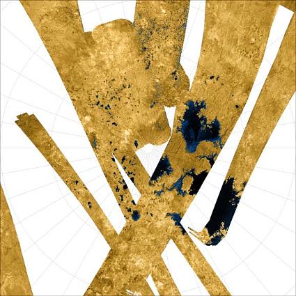
Titan’s North Pole
Like many striking astronomical images, this one is false-color; radar reflectivity is mapped to a particular color in order to produce a more accessible (and appealing) image. Here NASA scientists have taken the liberty of making the particularly smooth regions—areas that they suspect are actually liquid hydrocarbon lakes—a deep sea-like blue. So while the map is nice, if you ever found yourself orbiting Titan at some point in the future, you’re not going to see anything like this as you gaze out the window.
State Border Anomalies
A collection of small, odd state boundary features. The maps below are linked to the specific area on Google Maps to get a wider perspective. Links to the town names generally discuss why the particular feature exists, but for the most part they are the result of survey lines meeting geographical features in unanticipated ways.
The town of Southwick, Massachusetts extends two and a half miles into Connecticut along the boundary establish in 1804:
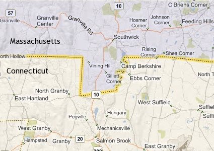
Southwick, Massachusetts
A small western portion of Virginia cuts back eastward into West Virginia. There is even a smaller bulb extending off that with a neck only 200 feet wide near the unincorporated community of Wyoming City:
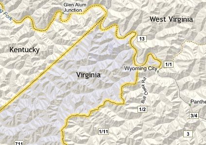
Hurley, Virginia
The far western portion of Kentucky contains a polyp extending off Tennessee around a segment of the Mississippi River known as The Kentucky Bend:
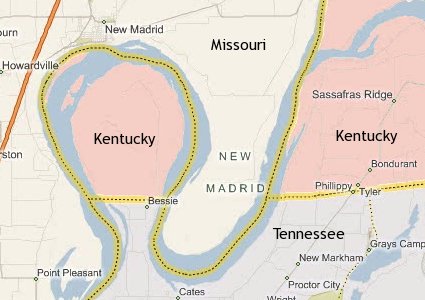
The Kentucky Bend
The village of Beecher Falls, part of the town of Canaan, Vermont, juts like a dagger into the northern reaches of New Hampshire. This is perhaps my favorite one because of all the time I’ve spent looking at maps of this region, I never even noticed this until a couple of years ago:
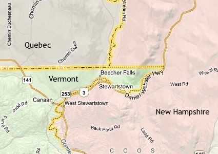
Beecher Falls, Vermont
Gnarly.