escutcheon

1722 Bonner Map of Boston

This is the map that I really wanted to see in Google Earth, the earliest complete map of Boston, created by Capt. John Bonner in 1722. It shows all the original shoreline before any major landfills had begun and the population was a mere 10,000.

Boston 1722 on Google Earth

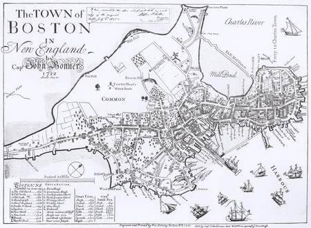
Original 1722 Bonner Map of Boston

Lining this up with the current street layout is just about impossible because of slight errors in the original map itself, but it is still pretty close. The old burial ground near the Boston Common is plainly visible, as is the original town dock (now Dock Square in the middle of the city in front of Faneuil Hall.)

Boston 1722 on Google Earth

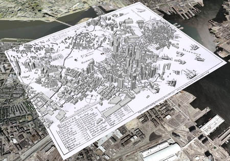
1722 Bonner Map of Boston rendered in Google Earth

A larger version of this image is available here.

If you would like to explore this map, the layer can be downloaded using this KML file: bonner.kml. The underlying map image is pretty large, about 1.5 megs so it may take a few seconds to fully load into the application. Click on the “3D Buildings” option to see the topographical changes stand out more sharply. Use the navigation in the upper right-hand corner to change the angle and otherwise move through the map.

» Posted: Friday, November 17, 2006 | Comments (12) | Permanent Link
fleuron

Comments

I have this map. I’ve had it for over 20 years. I need to know if it is authentic. Can you help

» Posted by michelle on January 10, 2007 12:18 AM

There’s really no way for me to tell. Your best bet would be to find a reputable map dealer near to where you live so that you can have them look it over in person.

Other, later editions of this map exist. The original plate was updated several times in the 18th century to reflect changes in the city itself, such as the filling-in of Dock Square and the building of Faneuil Hall, etc.

Many modern reproductions of the map also exist, so having someone who knows what they are doing, who can look over the map itself, is the only way to really judge its authenticity.

» Posted by xefer on January 10, 2007 02:50 PM

I also have a old map as shown above and the fine print says: Engraved from a copy in the possesion ofWm Tayor Esq. and published by:
George G Smith Engraver
1867
It was purchased as a gift to me many years ago because of my relationship to Gov. Thomas Dudley.
None of my children care so I could be interested in selling.
Edward Joseph Thomas Dudley

» Posted by Edward J Dudley on April 12, 2008 11:55 AM

I also have a map that says the same things on it as Mr. Edward Dudleys map. Yet all the pictures online do not have the extra engravings. Also the paper used says “COLD SPRINGS BOND”. The other words on the paper, which is hard to read all of it unless I take it out of the frame are “Permanized” and “Content”. I have searched online for any paper company that has “COLD SPRINGS BOND” and have had no luck. Can anyone tell me if this map is a copy or any information on the paper company.

» Posted by Sean Fox on April 28, 2008 01:43 PM

To whom it may concern,

I am writing to request your permission to use this image of the Bonnert map in
> Salem’s Witch House: The Haunting Landmark at Salem’s Old Crossroads by John
> Goff, scheduled for publication by the History Press in 2009.
>
>
> Based in Charleston, South Carolina and Salem, Massachusetts, The History Press publishes high quality history and heritage titles with a particular focus on topics of local and regional interest. Salem’s Witch House looks at the architectural history of Salem through the lens of one of the city’s most notable landmarks. The first run will be approximately 1500 copies and the book will be marketed locally in Salem, which is a city of 40,000 population.
>
> The turnaround for this request is very tight as the publisher is moving quickly to bring this project to completion. All image permissions have
> to be finalized by Thursday September 25, or sooner, if possible.
>
> While I realize that fees are sometimes associated with the rights to use an image, I’ll say up front that this is not a big budget operation. It is a project of quality, however, with accurate and thorough research
supporting it. To that end The History Press would be happy to provide you with a complimentary copy of the published product in lieu of payment to use your image/s. You can learn more about The History Press and review
their previously published titles by visiting www.historypress.net
>
> If your reply to this request is in the affirmative, please provide all of the information that you require in the citation if it differs from or is absent from the list above. If you have questions about this inquiry that are better discussed “live”, please contact me at 978-542-7890 (EST).
>>>
> Thank you for your consideration.

Karen Gahagan

» Posted by Karen Gahagan on September 20, 2008 04:16 PM

Have downloaded bonner.kml 2 or 3 times, but it is only 1 kb (493 bytes). Obviously nothing displays in Google Earth. Like to have this if possible. Any suggestions? Thanks,

John Morrison
Volunteer Docent
Boston by Foot

» Posted by John Morrison on October 19, 2009 12:58 AM

I work as a seasonal ranger on the Freedom Trail and use the Bonner ALL the time, esp at Faneuil Hall. You have done a fantastic job. It rocks!

» Posted by Dory Codington on January 15, 2010 07:46 PM

I have 2 middle names the B is for Bonner which was my great grandmothers maiden name.Effie Lydia Bonner.I also own a copy of this Boston map.My grandmother told me that This John Bonner was one of my ancestors.The map I have has been framed for many yrs.And is only 8’x6’1/4 im sure its probably a copy.

» Posted by D.C.B.Martin on February 23, 2010 06:45 PM

I am doing research for a book I’m writing that starts out in Boston in 1722. Thank you for making this available. Now I can move my characters around Boston on the correct streets.

» Posted by Jake on May 27, 2010 11:06 PM

I have a map of Boston by Capt. John Bonner

» Posted by Anonymous on June 13, 2010 08:05 AM

I have an original engraving of this map. The frame is original, bubbles in the glass, board backing, and square nails. The map is stained, but still in one piece. Very interesting to have a bit of history.

» Posted by Joanne on August 11, 2010 09:16 PM

I have been recreating a series of Old Boston Maps, and have 3 of the Bonner maps done. Check them out at scribedan.com

Will be having a show at a local gallery before the end of the summer.

» Posted by Dan Mooney on April 3, 2011 08:51 AM