escutcheon

1418 Chinese Map of the World

The moment I saw the recently discovered Chinese map of the world purporting to be a copy of one from 1418, I knew that it is not what it is claimed to be. It may very well have actually been printed in 1763, but I doubt very much the depictions of the Americas are from the early 15th century as the text on the map claims.

Chinese Map of America 1418

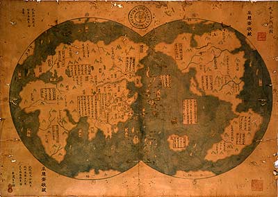
The two details that immediately jumped out to me were, one, the depiction of what appears to be California as an island, and two, the area of the Arctic with what looks like a land mass separated by great ocean streams.

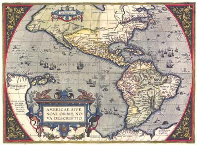
The earliest maps of California from the 16th century depict it correctly—as a penninsula. It wasn’t until the early 17th century that it started to be shown as an island. A recent article in The Economist about this map isn’t very clear on this particular point, seeming to imply in fact that the error is a point in favor of its authenticity. The idea that California was actually an island was based on Antonio de la Ascension’s journal of the 1602 voyage of Sebastian Vizcaino. The first time it appeared as an island was on the title page of Antonio de Herrera’s Descripcion de las Indias Occidentales (1622).

Notice here on Abraham Ortelius’, Americæ Sive Novi Orbis (1587), that California is shown correctly:

Americæ Sive Novi Orbis 1587

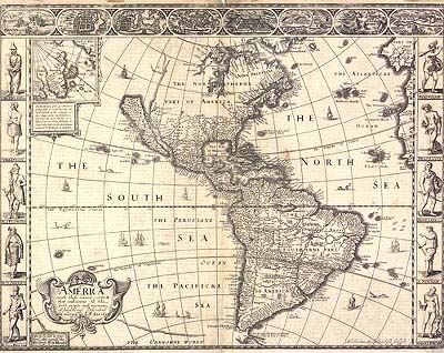
But by the 1630s many of the great Dutch and English map makers began to incorporate the error first shown by de Herrera. Here is an example from John Speed’s Atlas based on Abraham Goos, America (1626)

America 1626

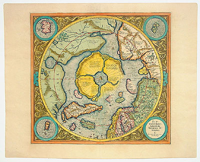
The map’s depiction of the Arctic also bears an interesting resemblance to Gerhard Mercator’s maps showing a northern land with great ocean streams emerging from the pole. Mercator had incorporated mythologies of an open polar sea with a great black rock at the pole itself. For example, Mercator, Septentrionalium Terrarum descriptio (1595)

Septentrionalium Terrarum descriptio 1595

I believe these details show that the Chinese map has actually incorporated the same errors that are depicted on European maps of the 17th century.

» Posted: Friday, January 20, 2006 | Comments (7) | Permanent Link
fleuron

Comments

It is most likely that the map is a recent copy of a 18th century map which has been “Chinesed” and may even use original paper.

» Posted by Laurence Mann on February 23, 2006 07:57 AM

Is it not equally likely that the Europens inherited Chinese faults in their map??? stoping thinking about this ia a traditional European way, CHina in 13/14/15th Century was light years ahead od europe, it only makes sense that the map was copied off the Chinese. Likewise, might I add, if the Chinese maps is a 18th Century fake or copy, then why is it that England, the greatest maritime of that time is omitted from the copy? It simply does not make sense for it to be unless it was omitted on the original 1418 map.

» Posted by Johnson on April 6, 2006 05:21 AM

the chinese didn’t invent maps. the vikings did. they had magic, runed stones that had magic powers that they threw ahead of them so as to listen for danger and then they just drew ground and uh water that they passed over

TRUEAMERICANHERO

» Posted by TRUEAMERICANHERO on May 31, 2010 10:13 PM

At the time, it would make sense to ommit britain. China was pissed.

Its a fake. No one gets the far corners of the world that right and messes up on neighboring territory. Its clearly copied from European maps.

» Posted by Anonymous on June 12, 2010 10:10 PM

Where is Norway,Sweden,Finland,Great Britain and Ireland in the first map.

» Posted by Scottish Guy on July 6, 2010 03:39 PM

Good day,

I just wanted to contact you in regard to these maps that you have posted. I work for a PBS affiliate, KQED, and we would be interested in using a couple of these maps in an episode we are currently producing. If you still have a high resolution jpeg of these maps or could direct me to where you found them. Please contact me at the email address provided, and maybe we could include a credit in this episode for you.

Thank you,
Michael Goode

» Posted by Michael Goode on February 9, 2011 01:48 PM

The Spaniards were the most advanced cartographers at that time not the dutch and the english. You forget that Spain was a global super power for centuries at that time and they were the most advanced cartographers at that time.

Did you notice that Spain is the centre of the world in all common maps in the west? ;-) Why do you think is that so? Guess :-D.

As for the chinese. Of course they lie and cheat and their map is a fake. I mean, we all know that chinese are born liars and cheaters. And they even suck in that. China is ridiculous.

» Posted by effect on September 17, 2013 06:07 AM